|
GEOSEARCH | PURPOSE | STRUCTURE | PRICING
ASSET VALUATION | ASSET ANALYSIS | MARKETING | RESEARCH
TOP MANAGEMENT
Detail of GeoSearch Program
| GeoSearch |
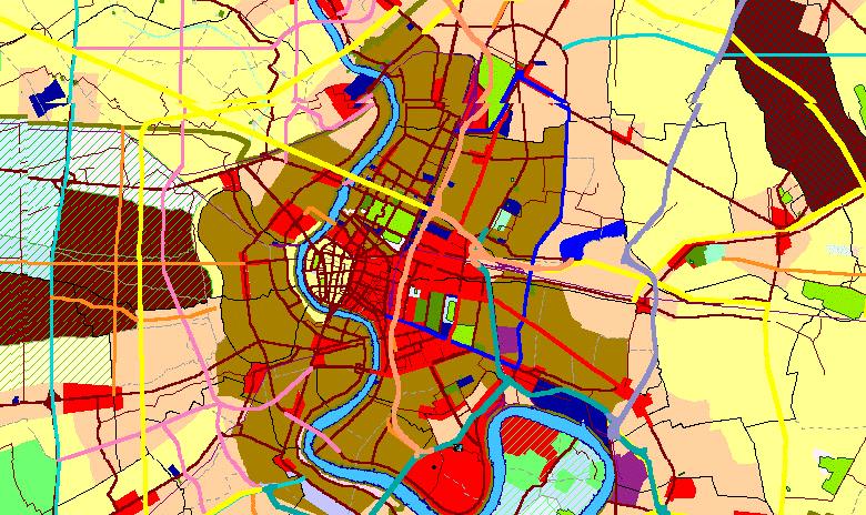
A ready-to-use property
information system (PIS) that contains basic and necessary data, specially
designed for banks and financial institutions. The components of GeoSearch
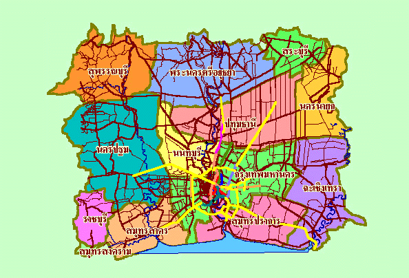
provided include a 1:20,000 scale map of Bangkok and its eleven vicinity
provinces, active housing projects, a sampling of over 200 land valuation
sites, new roads, color-coded zonings, population density and other
demographic data. The program allows users to create their own layers and
data records that link to the unlimited points on the map and, at the same
time, pool all relevant files, pictures and graphs to that particular
record. One obvious benefit is that it saves time and resources in the
loan department. This is because staff can preliminarily estimate
collateral value for customers by comparing the values of the new site to
values of the nearest existing sites or the nearest housing projects shown
on the map. All data that is provided by AREA, such as housing projects,
new roads etc., will be updated annually. |
| Purpose of
the program |
The program will help
collect, sort, retrieve and display the organization’s data which links
to points on the map. The asset price can be easily compared with
available information which has a direct impact on the asset value. |
| Structure of GeoSearch |
The package of a stand alone unit costs Bt290,000 (excluding VAT)
Contains:
- Software GIS,
- Application,
- A 1:20,000 scale map of Bangkok and 11
adjacent provinces,
- Data provided by AREA for price comparisons
is:
- More than 2,000 active housing projects,
- More than 200 land valuation price,
- New road projects,
- Future expropriation zones,
- Color zoning,
- Density of population.
- User data entry unit.
The five components of
information will enable users to start operating GeoSearch from day one without
having to further develop the program. |
| Pricing |
| GeoSearch |
License |
Per Seat |
Total |
| Model CS20k: Client/Server Virsion |
1 |
290,000 |
290,000 |
| 2-4 |
269,000 |
1,097,000 |
| 5-9 |
222,900 |
2,211,500 |
| 10-19 |
162,000 |
3,831,500 |
| Model Intranet20k:
Intranet Web Application (Unlimited License) |
1 |
N/A |
11,409,000 |
Prices above not include VAT
Prices above include necessary training and
maintenance for one year. |
The Benefit of
GeoSearch to Your Organization
Benefits for asset valuation
-
Helps you collect your data that refers to a
particular point on the map. At the same time, all relevant files, such as
site plan, pictures of the project or the house, title documents etc., can be
linked to the pre-defined fields in each record of your data.
-
Sorts information easily and shows the relevant
point on the map. As locations are plotted on the map, you can easily see the
difference or similarity of collateral. For example:
two or more assets have
different locations that could mislead a valuer to think that they are far
from each other. However, when located on the map, these assets are actually
situated very close to each other or just across a road. Hence, their values
should be closely related.
Or
two or more assets have the
same locations that could mislead a valuer to think that their values should
be similar. However, when located on the map, these assets are located in
different color zones. As a result, values can be highly divergent.
-
You can preliminarily estimate the value
of assets by comparing the new asset to the nearest existing assets
compiled by your organization. In addition, you can compare the new
asset with AREA’s housing projects information. The comparison will
let you know the asset potential & initial value.
-
You can sort more complicated
information by keying-in the sorting conditions. For example, you
would like to re-value a particular group of collateral that has a
value exceeding 25 million Baht and the latest valuation date was in
mid-1999. The program sorts and then displays the result
instantaneously.
|
|
|
Benefits for asset analysis
-
You can improve the
efficiency of the marketing department, estimating the asset value in the
bank’s database before conducting a real valuation. By comparing a
client’s assets to the bank’s existing data, together with AREA’s
housing project prices on the map, a loan officer can more accurately
estimate the size of the loan. In addition, the complete picture of the
organization’s assets will enable you to make efficient decisions in loan
granting, asset dissolving, and asset management.
|
 |
|
Benefits for marketing
-
Data from more than 2,000 active housing
projects acquired by AREA’s intensive field surveys will be very useful to
the post financing business. An officer can check the name of the
developers, type of developments, locations, percentage of completion and
proportion of sales, for example, in order to make a timely post finance
decision on favorable projects. Construction & decoration companies can
also sell their material to new houses. The crucial point is that all
related information will be updated annually , with a minimum fee.
Benefits for research
-
Using the information provided by AREA, the
research department will be able to extend analysis on the trends of the
real estate industry, particularly in the housing sector, population density
and location potential.
Benefits for top management
Management are able to view the
overall assets on the map since they can access information from all departments.
-
Management can see the risk dispersion of all
assets in the organization (after the assets are risk classified) and the
potential of each location that may not otherwise be seen from the report.
-
Management can easily retrieve all relevant
information of a particular customer or location because all info is stored
in the one place. This solves the problem previously encountered by
management of having to locate relevant information in different
departments.
|
|
 Contact:
market@area.co.th Contact:
market@area.co.th
GEOSEARCH | PURPOSE | STRUCTURE | PRICING
ASSET VALUATION | ASSET ANALYSIS | MARKETING | RESEARCH
TOP MANAGEMENT
|